Hurricane Season – High Velocity Hurricane Zones
 We are now well into the the 2010 hurricane season. Nothing major has occurred affecting South Florida, but it only takes that one storm. After living through an evening in August of 1992 with Andrew pounding on the doors, and the boarded-up windows of the home I was staying in west Miami-Dade, I am fully aware of the destruction that one storm can do. A long, and what seemed to be a never ending evening in darkness hearing what sounds like the thunder of a train going by for hours is something you never forget.
Back then, the South Florida Building Code was about as thick as a paperback romance novel. Hurricane Andrew put and end to that real fast! Now, almost twenty years later, the Florida Building Code fills a cabinet shelf with volumes and volumes of 3″ loose leaf binders. Like any government generated rules and regulations some is genuine and serves the purpose it was created for, but other portions are created with political motivations. That leads me to the following observations. As you can see by the map to the above left, the yellow areas are considered, high velocity hurricane zones. The yellow areas encompass all of Miami-Dade County and Broward County, and a portion of Palm Beach County. Within the yellow areas there are degrees of wind velocity. They range from 120 mph -150 mph, but what is 30 mph between friends. If you look closely, the highest wind velocities are at the tip of Florida, concentrated on the eastern coast.
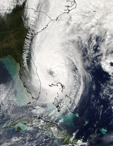
I am not a scientist, an engineer or a meteorologist but I am a thinker. Hurricanes have hit Florida from the Gulf as will as the Atlantic. Wilma in 2005, which I had the pleasure of experiencing, hit Florida on the Gulf side and went northwest through Florida. They also just don’t hit the tip of Florida as the wind borne debris map seems to indicate. When you look at the below satellite photos of Andrew and Wilma, and then compare it the the high velocity hurricane zones you are probably scratching your head.
So! My point is, get prepared and be prepared no matter where you live in Florida. Hurricanes are not going to follow maps created by bureaucrats. Also! It’s a little late now, but in the future, if you are doing any construction, build it to withstand 150 mph winds. You can always build to exceed Code!


